District Staff is available to answer questions regarding soil erosion and natural resource management. Soil Surveys, aerial photographs, USGS maps, fresh water wetland maps and FEMA flood insurance maps are on file and can be utilized to help answer your questions.
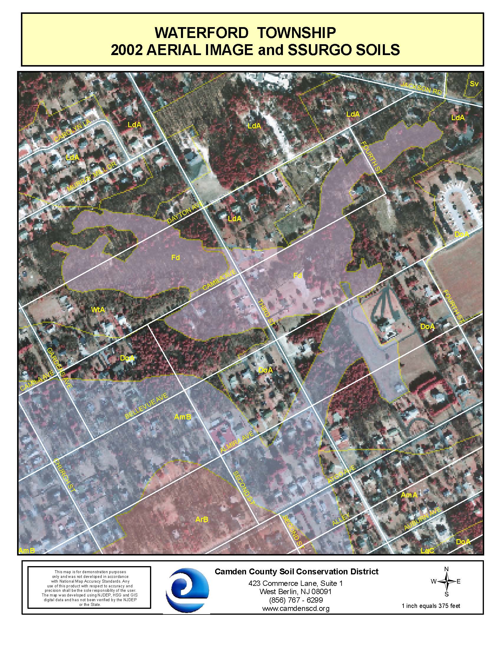
The District is now offering maps produced on Geographic Information Systems (GIS). With this technology, District staff is able to produce maps with multi-layered information such as wetlands, soils, aerial photograph for a particular site or project.
To utilize the technical resources available in the District Office, the District asks that you call ahead to make an appointment. This is to ensure that a staff member will be available for your particular questions and needs.
SESC Technical Bulletins
Clarification & Guidance on the applicability of Soil Erosion and Sediment Control Program
Clarifying information on the use the DelMarVa Unit Hydrograph
Applicability of the Standard for Offsite Stability on Cultivated Lands
Use of the DelMarVa Hydrograph in the Coastal Plain
Documenting Stablity on Existing Commercial Lots
USDA-NRCS Revisions to 24-Hour Design Storm Depths
Applicability of Web Soil Survey Data to Chapter 251 Projects
Soil Surveys
The United States Department of Agriculture – Natural Resources Conservation Services (USDS-NRCS) has developed an interactive Web Soil Survey for more than 95% of the nation’s counties with anticipation for 100% in the near future. The Web Soil Survey is the official soil survey for all of New Jersey, according to NJ Technical Bulletin 2006-1.0.
Click here to view the Web Soil Survey...
The District has the soil survey (obsolete version 1961) available on CD upon request for $15.00. If you would like a soil survey mailed to your home or office enclose your name or company name, phone number address, and a check made payable to the Camden County SCD.
The District is now offering maps produced on Geographic Information Systems (GIS). With this technology, District staff is able to produce maps with multi-layered information such as wetlands, soils, aerial photograph and topography for a particular site or project. These maps can be used for submittal to the Pinelands Commission, NJDEP, municipal tax officials, or other state and local government agencies. For more information, please contact the District Office.
Engineering Resources
- USDA-NRCS Electronic Field Office Technical Guide (Updated May 8, 2023)
- Hydric Soils of New Jersey (Updated May 8, 2023)
- State Plane Coordinates
- US ACOE HEC Homepage
- USDA-NRCS Web Soil Survey
- Win TR-55 Updated December 5, 2017
Services
The District offers a variety of services to the general public, local governments, land owners and local businesses. These services are as follows:
Stormwater Infrastructure - perform inspections, assessments and generate reports (includes GPS coordniates of structures, GIS datasets, watershed maps, as well as additional findings/observations). A benefit of this service is that no public bid is required since it could be performed through inter-local governament agency.
Stormwater Implementation Grants - provide grant writing, project management and administration. The District has developed many partnerships throughout the years and continues to apply for grants to implement projects identified through approved Stormwater Management Plans.
Open Space Inventory, Assessment & Management - perfom inspections, assessments and recommend management strategies to municipal and county owned open space, farmland and parkland.
Surface Water Quality Monitoring - perform a variety of water quality monitoring activities to determine potential problems within their region. At a minimun, the District can monitor temperature, dissolved oxygen and pH through our certified lab and collect samples for various pollutants and bacteria. The following monitoring programs are available:
- Stream Monitoring Program - perform monitoring for the above parameters and could include installation of water level logger(s) and staff gauge(s) that record continuous water levels.
- Lake Monitoring Program - perform monitoring for the above parameters and could include diurnal dissolved oxygen samples.
If you are interested in the above services, please contact the District for further inquires.
Aerial Photographs
Aerial Photographs can be very useful tools in the field of natural resource management, historical research, or in the preparation to build a home. The District has black and white aerial photographs on file for county. We have aerials for 2002, 2000, 1995, 1970, 1957, and 1940.
Aerial photographs are for use only in the District Office. If you wish to view an aerial photograph, an appointment must be made. This is to ensure that someone from the District staff will be available to assist you with any questions or concerns.
The District is now offering maps produced on Geographic Information Systems (GIS). With this technology, District staff is able to produce maps with multi-layered information such as wetlands, soils, aerial photograph, and topography for a particular site or project. These maps can be used for submittal to the Pinelands Commission, NJDEP, municipal tax officials, or other state and local government agencies. For more information, please contact the District Office.
Wetland Maps
National Wetlands Inventory Maps of Camden County is available for use in the District Office. They are on topographic style maps and each type of wetland is identified according to its symbol. The maps were prepared by the U.S. Department of the interior and are used to identify and approximate the limit of fresh water wetlands in a specified area.
Wetlands maps can be very helpful in determining suitable habitats for certain types of wildlife and vegetation adapted to wetland areas, in determining the suitability of buildable land according to the set wetland buffer zones created and enforced by the State of New Jersey, or to anyone who is interested in wetland areas surrounding or part of a specific parcel of land.
The District is now offering maps produced on Geographic Information Systems (GIS). With this technology, District staff is able to produce maps with multi-layered information such as wetlands, soils, aerial photograph and topography for a particular site or project. These maps can be used for submittal to the Pinelands Commission, NJDEP, municipal tax officials, or other state and local government agencies. For more information, please contact the District Office.
Topographic Maps
The District has U.S. Geological Survey topographical maps that cover all of Camden Counties and part of Atlantic, Burlington and Gloucester Counties. These maps portray the topography of the land and distinguish many features such as lakes, streams, roads, buildings, and wooded areas. In addition, county, state, and federal parks are delineated on the maps which can be very helpful when planning outdoor recreational activities.
The District is now offering maps produced on Geographic Information Systems (GIS). With this technology, District staff is able to produce maps with multi-layered information such as wetlands, soils, aerial photograph, topography, etc for a particular site or project. These maps can be used for submittal to the Pinelands Commission, NJDEP, municipal tax officials, or other state and local government agencies. For more information, please contact the District Office.
The District is now offering maps produced on Geographic Information Systems (GIS). With this technology, District staff is able to produce maps with multi-layered information such as wetlands, soils, aerial photograph, topography, etc for a particular site or project. These maps can be used for submittal to the Pinelands Commission, NJDEP, municipal tax officials, or other state and local government agencies. For more information, please contact the District Office.
GIS/GPSThe District has been using Geographic Information Systems (GIS) since 2001. GIS consists of computer hardware and the software needed to analyze data that has spatial distribution. This data can be point, line, or polygon (area) and contains a set of characteristics or attributes associated with the data.
Staff members are able to produce multi-layered maps consisting of aerial photographs, soils, wetlands, topographical information, streets, tax maps, and other vital information pertaining to the area of Camden County. From these databases, the District is able to produce new data layers and is able to make predictions on a multitude of questions that may arise for a particular project. For more information, please contact the District Office. |

